Geo Location
Introduction/Purpose:
The Geo Location Master in the procurement system is a comprehensive feature that allows for efficient management of geographic information related to various entities involved in the procurement process. The system consists of several interconnected master tables that store specific details about countries, regions, states, districts, and cities.
The main components of the Geo Location Master are as follows:
- Country Master: This module stores information about countries. It includes attributes such as the country’s name, code (a unique identifier), ISO code (International Organization for Standardization code), and dialing code (telephone prefix).
- Region Master: The region table is linked to the country table, enabling a relationship between regions and their respective countries. It stores region names and is associated with a specific country. This linkage helps in organizing and categorizing regions based on the corresponding country.
- State Master: The state table holds data regarding different states or provinces. It includes attributes like the state name, state code (a unique identifier for the state), and a reference to the country to which the state belongs. Additionally, there is an optional field to link a state with a region. This association allows for convenient filtering of records based on the selected region.
- District Master: The district table stores information about various districts within a state and country. It includes attributes such as district name, a reference to the state, and a reference to the country. By linking districts to their respective states and countries, the system facilitates proper organization and filtering of records.
- City Master: The city table holds details about cities. It includes attributes like city name, a reference to the country, a reference to the state, and an optional field to link a city with a district. This arrangement allows for easy filtering of records based on the selected district.
By structuring the Geo Location Master in this format, the procurement system enables users to input and retrieve information accurately. The interconnections between the various master tables ensure that records can be properly filled, filtered, and categorized based on country, region, state, district, and city, as applicable. This structured approach enhances data integrity and improves the efficiency of procurement-related processes.
How To Navigate:
The navigation to record a Geo Location in a procurement system typically involves the following steps:
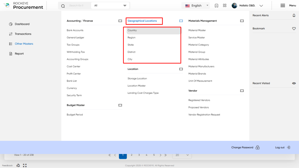
- Click on the main navigation icon: The main navigation icon may be located in the top right corner of the screen. Clicking on this icon will open the navigation menu, which typically includes links to various sections of the procurement system.
- Click on the Other Master section: The Other Master section is located under the left section of the screen clicking on this section will display a list of masters related to procuring.
- Find the Geographical Locations section: The Geo Location section is located in the list of masters under the Master section. Clicking on this section will display a list of masters related to geographical locations.
- Click on the Country/Region/State/District/City link: The Country/Region/State/District/City link is located under the Geographical Locations section. After clicking on this link, you can navigate Country/Region/State/District/City in the listing, and from that you can easily upload new transactions into the system.
Listing:
In a procurement system, the geolocation listing provides a comprehensive view of the geographic data stored in the system. Here is a description of the geolocation listing features:
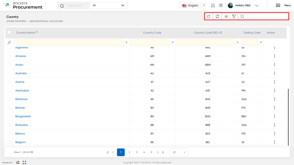
- Sync With FINAS System: The Geo Location listing is synchronised with the FINAS system, ensuring that the geographic data remains consistent and up-to-date across both systems. This synchronisation allows for seamless integration between procurement processes and financial systems.
- Extra Options: The geolocation listing provides additional options to enhance user experience and functionality. These include conditional search, show all, column customisation, and export capabilities. Conditional search enables users to filter records based on specific criteria. The “show all” option displays all available records in the listing. Users can also customise the columns displayed in the table view and export the listing data for further analysis or reporting purposes.
- Filter: The listing includes a filtering mechanism that allows users to refine the displayed records based on various parameters. Filters can be applied to narrow down the view by country, region, state, district, city, or other relevant attributes. This enables users to focus on specific geographic areas or criteria of interest.
- Search: The Geo Location listing provides a search functionality, allowing users to search for specific records within the listed data. This search feature facilitates quick access to desired geographic information, saving time and effort.
- Listing: The Geo Location listing presents the data in a table view format for the different masters, including Country, Region, State, District, and City. Each master’s records are organized in rows and columns, providing a structured and easy-to-read representation of the geographic data.
- Activity Log: Within the listing, users have the ability to access the activity log for each selected record. By clicking on the “other options” menu for a specific record, users can view the activity log, which captures any relevant changes, updates, or actions performed on that particular record. The activity log provides an audit trail, enabling users to track and review the history of modifications made to the geographic data.
Overall, the geolocation listing in the procurement system offers a centralised and organised view of geographic data. It provides users with various options to search, filter, customise columns, and export data. The table view format enhances data visibility and accessibility, while the activity log ensures transparency and traceability of record changes.
Clickable Action:
The Geo Location Masters in a procurement system can be created by only syncing with the Financial Accounting System (FINAS). If synced with FINAS, records cannot be edited in the procurement system.
Overall, the geolocation master records and update summary in the procurement system enable efficient management and tracking of geographic data. They provide a clear overview of the existing records, highlight recent updates, facilitate record creation and modification, and contribute to data validation and integrity within the procurement system.
Key Notes Geo Location Masters:
- Geo Location Masters are usually synced with the FINAS system if integrated, accomplished by selecting “Sync” from the Geo Location Masters listing.